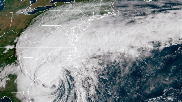
(WASHINGTON) — A little over a month since the National Oceanic and Atmospheric Administration (NOAA) announced that it and the National Weather Service (NWS) would no longer be receiving critical satellite weather data used in forecasting hurricanes, the Department of Defense now says it will continue to provide the agencies information from the Special Sensor Microwave Imager Sounder (SSMIS).
The U.S. Navy told ABC News that its Fleet Numerical Meteorology and Oceanography Center “had planned to phase out the data as part of a Defense Department modernization effort. But after feedback from government partners, officials found a way to meet modernization goals while keeping the data flowing until the sensor fails or the program formally ends in September 2026.”
The Navy previously told ABC News in a statement that “We can confirm that the Navy’s Fleet Numerical Meteorology and Oceanography Center will no longer contribute to processing and disseminating Defense Meteorological Satellite Program data on July 31, 2025, in accordance with Department of Defense policy. DMSP is a joint program owned by the U.S. Space Force and scheduled for discontinuation in September 2026. The Navy is discontinuing contributions to DMSP given the program no longer meets our information technology modernization requirements.”
The SSMIS instruments are part of three weather satellites that are in low-Earth orbit and are maintained by NOAA in cooperation with the Department of Defense. They provide critical weather information that can’t yet be replaced by other satellites and weather instruments, according to NOAA.
The SSMIS offers forecasters the ability to examine the inner workings of active tropical systems and to better understand their behavior. Specifically, the tool uses microwaves to penetrate clouds and obtain a clearer picture of the inner structure of a tropical cyclone. This enables forecasters to better monitor the current progress of such storms, including the ability to identify the exact center of the weather system for use in creating forecast models.
Other weather satellites use visible and infrared imagery, which can only capture surface-level details of the cloud tops of such storms, rather than what’s happening inside of them. These satellites also are ineffective after sunset, when it’s too dark to see and when direct observations over open water are scarce. Because the SSMIS system doesn’t have these limitations, forecasters rely on the data it collects during such periods.
Weather forecast models are sensitive to initial weather conditions and rely on multiple sources of accurate weather data for forecasting. Any degradation or discontinuity in the data, whether in terms of quality or quantity, could negatively affect the model’s forecasting skill, scientists warn.
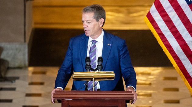
Nebraska Gov. Jim Pillen; Bill Clark/CQ-Roll Call, Inc via Getty Images
(FREMONT, Neb.) — A man and two children were killed in a large explosion at a Nebraska plant, officials said Wednesday.
The incident occurred midday Tuesday at Horizon Biofuels, a manufacturer of fuel pellets and animal bedding located in Fremont, located approximately 40 miles northwest of Omaha.
The three people were missing following the explosion, with search efforts hindered by the fire and structure concerns, Fremont Mayor Joey Spellerberg said. The response has since moved to a recovery effort, as crews continue to battle the fire, authorities said.
“My heart hurts,” Spellerberg said during a press briefing on Wednesday. “It hurts for this situation, which is a tragedy. We pray for all the families involved.”
The employee was in building with two girls who are believed to be under the age of 12 when the explosion occurred, the mayor said. Their names are not being released at his time, he said.
“The two children were there just waiting for him to get off to go to a doctor’s appointment,” Spellerberg said.
Crews are continuing to battle an active fire on Wednesday and assessing how to safely access the building to recover the victims, Nebraska Task Force One program manager Ashley Engler said during Wednesday’s briefing. The steel warehouse is becoming more unstable as the fire continues to burn, she said.
“We are using all search and rescue resources and capabilities we have, including structural engineers, to obtain access in a safe manner to get to these to these victims,” she said.
Responding firefighters were initially met by “heavy smoke and a lot of flames coming out,” Fremont Fire Chief Todd Bernt said during a press briefing Tuesday afternoon. “We had a lot of structural collapse.”
Fire crews were unable to access the building to conduct a search, Bernt said.
“Early on, we tried to get access, but just due to the collapse with the mangled steel, we were unable to get inside,” Bernt said.
Due to the structural issues, the fire department requested support from Nebraska Task Force One, the chief said.
Bernt said the plant has a lot of wood and some alcohol-based materials stored inside.
The cause of the explosion remains under investigation. The Nebraska State Fire Marshal’s Office and other agencies were on scene.
Nebraska Gov. Jim Pillen said he is closely monitoring the incident.
“Our thoughts and prayers are with all involved — and we’re ready to help any way we can,” he said in a statement Tuesday.
One woman who came out to the scene to give out water to first responders on Tuesday said she saw a “large black puff of smoke” following the explosion.
“I was just instantly praying that nobody was hurt,” she told reporters. “That’s all we can hope for. We’re a good community. Everybody will rally together and help each other.”
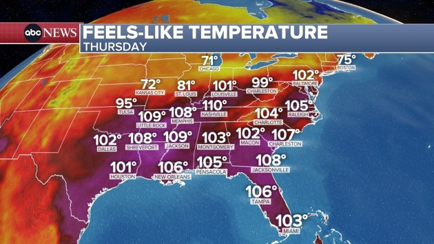
(NEW YORK) — Over 120 million Americans across 28 states remain on alert for dangerously hot and humid weather on Wednesday as a heat wave continues to bake the eastern half of the country. But relief is on the way beginning Thursday in the Northeast.
Parts of Louisiana and most of Mississippi are under extreme heat warnings on Wednesday, with heat indices — what the temperature feels like with humidity — reaching up to 120 degrees.
Memphis, Tennessee, which is under an extreme heat warning, could see a heat index reaching 115 degrees on Wednesday.
Washington, D.C., could reach a heat index of up to 109 degrees on Wednesday, while it will feel like 104 degrees in Philadelphia and 102 degrees in New York City. For actual temperatures, Philadelphia and Baltimore could reach a daily record high of 99.
New York City marked an official heat wave on Wednesday as it reached 90 degrees for a third consecutive day.
But, a significant cool down will arrive in the coming days.
St. Louis, which has felt like over 110 degrees for more than a week, will finally see temperatures in the 70s on Thursday.
On Friday, highs will reach near 70 degrees from Philadelphia to Boston.
Unfortunately, the extreme heat will continue in the South over the coming days.
Throughout the weekend, high temperatures and humidity will remain in the Deep South, with the extreme heat expecting to hold along the Gulf Coast. A new heat dome may also form over the desert Southwest.
For tips on how to stay safe in a heat wave, click here.
(WASHINGTON) — The National Transportation Safety Board began its three days of investigative hearings on Wednesday into January’s midair collision between American Airlines Flight 5342 and a Black Hawk helicopter near Washington’s Reagan National Airport.
On Wednesday morning, the NTSB released thousands of pages of evidence from the crash and the subsequent investigation — including new video from the end of the runway showing the crash that killed 67 people.
Families of the victims of the crash sat in the audience of the hearing, some of whom wore pictures of their loved ones around their necks or on buttons. They broke down in tears as officials played the video with newly released surveillance footage of the incident.
The crash involved a regional jet that was flying from Wichita, Kansas, into Washington and collided with an Army helicopter on a training flight, killing all 64 passengers and crew on the jet and the three crew members in the helicopter.
During the three-day hearings, the NTSB is expected to question the Army, Federal Aviation Administration officials and others, and present its finding on the crash investigation. The NTSB will focus on a variety of topics in the hearings. The first day will focus on the helicopter’s altimeters and data systems as well as the design and use of the airspace around the airport.
“We’re going to focus on [air traffic control], so air traffic control and training, guidance, procedures, what was going on in the air that night, and again, that is within FAA’s purview,” NTSB Chair Jennifer Homendy told reporters on Tuesday.
The NTSB will also discuss collision avoidance systems on aircraft as well as any safety data that was available and unavailable and how safety management systems can be implemented and improved.
Witnesses who are testifying at the hearings include personnel from the Army, American Airlines and the FAA.
On the eve of the investigative hearings, Republican Sen. Ted Cruz introduced legislation called “The Rotor Act,” which would require all aircraft, including military, to transmit ADSB location when flying — a system that allows aircraft to transmit its location to other aircraft as well as to air traffic controllers. All aircraft flying above 18,000 feet are required to have ADSB, but certain aircraft, including military aircraft, are exempt from transmitting ADSB location for security reasons.
Transportation Secretary Sean Duffy said the NTSB recommended to the FAA to require ADSB on all aircraft nearly two decades ago.
“ADSB, and I can’t stress this enough, is a game-changer, a game-changer when it comes to safety and will provide, as we said in 2008 immediate and substantial contribution to safety. This will save lives. This legislation will save lives,” Homendy said.
In its preliminary report, the NTSB said there is no indication the Black Hawk crew could tell it was on a collision course with Flight 5342, which was landing at the same time the helicopter was passing the end of the runway.
The helicopter crew might have had bad information from their altimeter, which measures height, as the pilots had differing altitudes in the seconds before the crash, the NTSB said in its preliminary report in February.
“We are looking at the possibility of there may be bad data,” Homendy said at the time.
The crew of the helicopter might not have heard a transmission from the tower that instructed them to go behind the airliner because the pilot may have keyed her radio at the same second and stepped on the transmission from ATC, the NTSB preliminary report findings showed.
One helicopter pilot thought they were at 400 feet and the other thought they were at 300 feet. The NTSB said it was not prepared to say exactly how high the helicopter was at impact.
(WASHINGTON) — The National Transportation Safety Board began its three days of investigative hearings on Wednesday into January’s midair collision between American Airlines Flight 5342 and a Black Hawk helicopter near Washington’s Reagan National Airport.
On Wednesday morning, the NTSB released thousands of pages of evidence from the crash and the subsequent investigation — including new video from the end of the runway showing the crash that killed 67 people.
Families of the victims of the crash sat in the audience of the hearing, some of whom wore pictures of their loved ones around their necks or on buttons. They broke down in tears as officials played the video with newly released surveillance footage of the incident.
The crash involved a regional jet that was flying from Wichita, Kansas, into Washington and collided with an Army helicopter on a training flight, killing all 64 passengers and crew on the jet and the three crew members in the helicopter.
During the three-day hearings, the NTSB is expected to question the Army, Federal Aviation Administration officials and others, and present its finding on the crash investigation. The NTSB will focus on a variety of topics in the hearings. The first day will focus on the helicopter’s altimeters and data systems as well as the design and use of the airspace around the airport.
“We’re going to focus on [air traffic control], so air traffic control and training, guidance, procedures, what was going on in the air that night, and again, that is within FAA’s purview,” NTSB Chair Jennifer Homendy told reporters on Tuesday.
The NTSB will also discuss collision avoidance systems on aircraft as well as any safety data that was available and unavailable and how safety management systems can be implemented and improved.
Witnesses who are testifying at the hearings include personnel from the Army, American Airlines and the FAA.
On the eve of the investigative hearings, Republican Sen. Ted Cruz introduced legislation called “The Rotor Act,” which would require all aircraft, including military, to transmit ADSB location when flying — a system that allows aircraft to transmit its location to other aircraft as well as to air traffic controllers. All aircraft flying above 18,000 feet are required to have ADSB, but certain aircraft, including military aircraft, are exempt from transmitting ADSB location for security reasons.
Transportation Secretary Sean Duffy said the NTSB recommended to the FAA to require ADSB on all aircraft nearly two decades ago.
“ADSB, and I can’t stress this enough, is a game-changer, a game-changer when it comes to safety and will provide, as we said in 2008 immediate and substantial contribution to safety. This will save lives. This legislation will save lives,” Homendy said.
In its preliminary report, the NTSB said there is no indication the Black Hawk crew could tell it was on a collision course with Flight 5342, which was landing at the same time the helicopter was passing the end of the runway.
The helicopter crew might have had bad information from their altimeter, which measures height, as the pilots had differing altitudes in the seconds before the crash, the NTSB said in its preliminary report in February.
“We are looking at the possibility of there may be bad data,” Homendy said at the time.
The crew of the helicopter might not have heard a transmission from the tower that instructed them to go behind the airliner because the pilot may have keyed her radio at the same second and stepped on the transmission from ATC, the NTSB preliminary report findings showed.
One helicopter pilot thought they were at 400 feet and the other thought they were at 300 feet. The NTSB said it was not prepared to say exactly how high the helicopter was at impact.
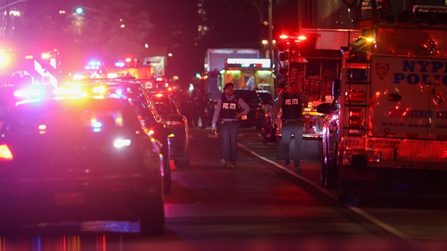
(NEW YORK) — After a gunman opened fire in a New York City office building and killed four people, experts expressed some concerns regarding security in workplace environments.
Four people were killed and one was injured on Monday after police say 27-year-old Shane Devon Tamura entered a Midtown Manhattan office building — which is home to the NFL headquarters — wearing body armor and opened fire with a high-powered rifle, according to authorities.
Donald Mihalek, a senior ABC News law enforcement contributor and retired United States Secret Service agent, said these types of workplace shootings are on the rise due to people — employees and those not affiliated with the company — feeling more comfortable with vilifying corporations and taking out their grievances through violence.
From 1994 to 2021, 16,497 U.S. workers were “intentionally killed while at work,” according to 2024 study. Other recent shootings that occurred at workplaces include the 2021 incident at an office complex in Southern California, killing four people, and a 2023 incident at a bank in Kentucky, killing five and injuring eight.
“Corporations are now feeling what governments have felt for many years, being targeted, being vilified,” Mihalek told ABC News.
So, what was learned from this incident and how can office buildings help mitigate these shootings from escalating?
Security outside an office building and artificial intelligence monitoring potential threats
On Monday, the suspect emerged from a double-parked BMW with an M4-style weapon Palmetto State Armory PA-15 rifle, entered the lobby alone, immediately opened fire on a New York Police Department officer and sprayed the lobby with bullets.
Richard Frankel, an ABC News contributor and retired FBI special agent, said Tamura’s ability to leave his vehicle double-parked and walk with a visible weapon “without anyone even thinking about it or causing concern” is “a little bit of an issue.”
“It’s crazy that he was able to walk on a Manhattan street into a building and not be seen carrying a long gun,” Frankel told ABC News. “How was he able to just walk with no one seeing him carrying an assault weapon and actually having it dangle out from his jacket?”
To prevent something similar happening in the future, Frankel said a corporation increasing its security presence outside the building — by establishing a private government partnership or hiring individuals — could help prevent the threat from actually entering the presence.
Frankel also said there is artificial intelligence and video technology used by federal buildings that could “observe what somebody is doing and consider whether that’s a threat or not.” If an armed individual is approaching the building, “an alarm would go off” with this technology, Frankel said.
Understanding the difference between handgun and rifle violence
With this shooting, the gunman opened fire using a rifle, which is a “more powerful weapon” that can travel a greater distance and has a greater capacity to penetrate compared to a handgun, Mihalek said.
Thus, corporations should think to make a “significant investment” in armor and bulletproof glass around the entranceways of the building, he said. While it is “very difficult” for someone to protect themselves from a rifle, a “man trap system” — where somebody has to be let through different phases of the building in order to get to the heart of the structure — could also help slow down the attack.
Conducting threat assessments
Mihalek also recommends that corporations conduct threat assessments, where a business identifies individuals — both employees and those not affiliated with the company — who may be potential threats of violence due to a recent termination, relationship turmoil or social media posts showing grievances toward the company or individuals at the company.
While it is unclear whether the suspect in Monday’s shooting was posting threats on social media, officials had found a note in his pocket accusing the National Football League of concealing the dangers to players’ brains to maximize profits, sources said. So “chances are he had some type of social media presence or online presence somewhere where he might have said a few things about the NFL,” which could have alerted of a potential threat beforehand.
This behavioral assessment is a holistic process that detects, identifies and processes potential threats, Mihalek said.
“This individual could have perhaps said something concerning online or elsewhere but if no one reports it or is looking, it can’t be detected,” Mihalek said.
Implementing active shooter drills, training for employees
Along with buildings implementing additional security and keeping a lookout for potential threats, both Mihalek and Frankel said corporations should implement routine active shooter drills and provide both online and in-person training conducted by local law enforcement.
Mihalek said buildings should also partner with local law enforcement and emergency medical services so they can “understand the layout of the building” so that they are prepared for a potential threat to that particular office space.
The Department of Homeland Security also has basic active shooter protocols instructing individuals in an active shooter situation to “run, hide and fight,” which Mihalek said is used in many schools and is “simple, effective and it works.”
ABC News’ Aaron Katersky contributed to this report.
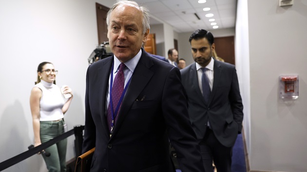
(WASHINGTON) — Steve Ricchetti, who served as a counselor to former President Joe Biden, is set to appear for a closed-door interview with the Republican-led House Oversight Committee on Wednesday as its chairman, Republican Rep. James Comer, continues his investigation into the former president’s mental fitness while in office.
Ricchetti is likely to appear voluntarily. The committee did not issue a subpoena for his testimony.
The House panel has requested interviews with several former Biden officials as part of their probe into the former president’s mental capacity while in office. Ricchetti is the latest of several former Biden administration officials who have appeared before the committee.
Last week, former Chief of Staff Ron Klain cooperated with the committee for several hours.
However, several other aides have not been willing to engage with the committee and invoked the Fifth Amendment, including Dr. Kevin O’Connor, the former physician to Joe Biden, and Annie Tomasini, who served as the deputy chief of staff to Biden.
Biden himself rejected reports of cognitive decline during an appearance on ABC’s “The View” in early May.
“They are wrong. There’s nothing to sustain that,” Biden said at the time.
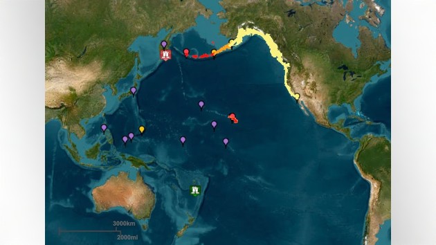
(LOS ANGELES) — A massive magnitude 8.8 earthquake struck off Russia’s Pacific coast, sparking tsunami warnings and evacuations of coastal areas in Hawaii and alerts along the U.S. West Coast.
Latest
In Russia, a camera captured the eruption of the Klyuchevskaya Sopka volcano — the highest mountain in the region — sending hot lava down its western slope.
In the U.S., President Donald Trump on social media urged people to “STAY STRONG AND STAY SAFE” and to monitor updates on the tsunami.gov online dashboard.
After the initial tsunami waves had washed ashore in Hawaii and along the West Coast on Tuesday, officials with the Pacific Tsunami Warning Center reduced the alert level for the Hawaiian islands to a tsunami advisory.
Gov. Josh Green told reporters early Wednesday that Hawaii had so far “not seen a wave of consequence, which is a great relief to us.” He added, “It’s kind of a blessing to not be reporting any damage,” though warned there could yet be more tsunami waves.
Tsunami waves were recorded in Monterey, California, as of 12:48 a.m., the National Weather Service said, and reached San Francisco at around 1:12 a.m. However, none had caused any significant issues.
Coastal areas of Alaska, Oregon, Washington and California remained under National Oceanic and Atmospheric Administration tsunami advisories as of Wednesday morning. A stretch of coastline north of Cape Mendocino, California, to the border with Oregon remained under a tsunami warning. A tsunami warning means a tsunami that could cause widespread, dangerous flooding and powerful currents is expected. A tsunami watch means a distant earthquake has occurred and a tsunami is possible.
Hawaiian Airlines and Alaska Airlines said they would resume flights on Wednesday morning after a pause due to the tsunami warnings.
Hawaii at center of initial warnings
The National Weather Service said just after 7 p.m. local time — 1 a.m. ET — that tsunami waves “were recently detected in Haleiwa.”
Just after 8:30 p.m. local time, the Hawaii County Civil Defense Agency said, “It’s not over yet: Initial wave impacts from the leading edge of the tsunami measured several feet at some monitoring stations, but ‘follow-up’ waves over the next several hours often are LARGER. Don’t return to evacuated areas until the Tsunami Warning is officially lifted.”
Waves of up to 4 feet were recorded off of Oahu, with no large waves reported near the Big Island.
In Hawaii, the NWS called for “urgent action” to protect lives and property.
Officials there urged residents to leave beaches and evacuate low-lying areas for higher ground or to take shelter on at least the fourth floor of a building. Sirens sounded across the Hawaii islands 10 minutes after each hour for the three hours leading up to the expected impact as a part of a statewide warning system.
Less than an hour before the waves were expected to hit, Green said officials were braced for a “significant wave” measuring 6 feet total, from peak to trough. “That means a 3-foot wave riding on the top of the ocean,” Green said.
All shores of the island are at risk because tsunami waves wrap around islands, officials said.
“The danger can continue for many hours after the initial wave as subsequent waves arrive. Tsunami heights cannot be predicted and the first wave may not be the largest,” the NWS said in an alert.
“It is not just a 3-foot wave, it is a forceful wall of water,” the governor said, adding that it’s possible such a wave could knock down utility poles and leave debris strewn in its wake.
Tsunami alerts for West Coast, around the world
In the wake of the quake, a tsunami warning was issued for part of Alaska’s Aleutian Islands and Northern California, from Cape Mendocino — located about 200 miles north of California — to the Oregon border. The rest of the California coast, as well as Oregon and Washington, were under a tsunami advisory.
The U.S. territories of Guam and American Samoa were also put under a tsunami advisory, according to USGS.
The intense quake occurred about 85 miles off the east coast of Russia’s Kamchatka Peninsula with a depth of nearly 12 miles, according to the U.S. Geological Survey. It was one of the most powerful earthquakes ever recorded by the agency, which upgraded its magnitude from initial reports of 8.0 and 8.7.
Magnitude 6.3 and 6.9 aftershocks were also reported in the area, according to USGS.
Damage was reported in Russia’s far eastern Kamchatka region, where emergency services said 3,000 people were evacuated.
All of northern Japan was placed under a tsunami warning, with more than 2 million people evacuated.
Japan’s meteorological agency warned that a tsunami about 3 feet high was expected to reach Hokkaido.
The Japan Meteorological Agency later revised tsunami warnings to lower level advisories, but said people should still exercise caution.
In Central and South America, tsunami warnings or watches were put in place by authorities in Chile, Peru, Ecuador, Costa Rica, Mexico, Guatemala, El Salvador and Colombia.
In the Pacific region, French Polynesia, Guam, Samoa, Solomon Islands, Fiji, Marshall Islands, Kiribati, New Caledonia, the Cook Islands, Nauru, Australia and the Philippines issued various levels of tsunami alerts, plus warnings of expected strong currents and possible flooding.
New Zealanders were advised to avoid beaches due to expected strong currents and surges.
U.S. territories in the Pacific including Johnston Atoll, Midway Island, Palmyra Island, Howland and Baker Islands, Jarvis Island and other nearby small islands were also put on alert for possible tsunami waves.
China issued tsunami alerts for Shanghai and Zhejiang regions, though those were later lifted.
ABC News’ William Gretsky, Anthony Trotter, Mireya Villarreal, Tanya Stukalova, Clark Bentson and Jessica Gorman contributed to this report.
This is a developing story. Please check back for updates.
US Treasury Secretary Scott Bessent (R) and US Trade Representative Jamieson Greer (L) held a press briefing on the outcome of weekend trade talks with China in Geneva, Switzerland on May 12, 2025. (Photo by Beyza Binnur Donmez/Anadolu via Getty Images)
(WASHINGTON) — The U.S. economy expanded more than expected as President Donald Trump’s tariffs took hold over recent months, federal government data on Wednesday showed.
U.S. gross domestic product, or GDP, increased at a 3% annualized rate over three months ending in June. The figure marked a sharp acceleration from an annualized contraction of -0.5% over the first three months of 2025.
The reading amounted to sturdy economic growth, suggesting the economy has continued to avert a significant tariff-induced cooldown. A boost in consumer spending helped propel the economic surge, the U.S. Commerce Department said.
To some degree, however, Trump’s levies have blurred the GDP findings.
The government’s GDP formula subtracts imports in an effort to exclude foreign production from the calculation of total goods and services. Changes in the reading on this account reveal neither underlying economic weakness nor strength.
The measure of the GDP fell over the first three months of the year, largely due to a surge of imports as firms stockpiled inventory to avoid far-reaching tariffs. Conversely, a drop-off in imports over the second quarter may have inflated the second-quarter GDP figure.
The GDP growth “primarily reflected a decrease in imports, which are a subtraction in the calculation of GDP,” the U.S. Commerce Department said on Wednesday.
The U.S. economy so far has largely defied fears of a tariff-induced downturn.
The unemployment rate stands near a historically low level and job growth remains robust, though it has slowed from previous highs. Inflation has climbed over the last two months but it remains below where it stood when Trump took office.
In the months following Trump’s “Liberation Day” tariffs, in April, consumer sentiment declined to its lowest level in years, raising concern about a possible pullback in consumer spending, which accounts for about two-thirds of economic activity.
Consumer sentiment has ticked up for two consecutive months, however, as Trump has rolled back some of his steepest tariffs. Consumer spending has proven fairly resilient.
Wednesday’s fresh GDP data arrived hours before the Federal Reserve is set to announce its latest decision on interest rates.
An overwhelming 97% of investors believe interest rates will hold steady, according to the CME FedWatch Tool, a measure of market sentiment.
In theory, sturdy economic growth eases pressure on the Fed to lower interest rates, since consumers and businesses appear undeterred by high borrowing costs. If growth begins to slow, the Fed could seek to lower interest rates as a means of boosting economic performance.
The Fed has adopted a wait-and-see approach as it continues to observe the effects of Trump’s tariffs.
“Despite elevated uncertainty, the economy is in a solid position,” Fed Chair Jerome Powell said at a press conference in Washington, D.C., last month.
(LOS ANGELES) — A massive magnitude 8.8 earthquake struck off Russia’s Pacific coast on Tuesday, sparking tsunami warnings — and evacuations of coastal areas — in Hawaii and alerts all down the U.S. West Coast.
After the initial tsunami waves had washed ashore in Hawaii and along the West Coast, officials with the Pacific Tsunami Warning Center reduced the alert level for the Hawaiian islands to a tsunami advisory. Local officials in Oahu said just before 11 p.m. local time that evacuees who’d moved to higher ground on the island could begin returning.
Gov. Josh Green told reporters early Wednesday that Hawaii had so far “not seen a wave of consequence, which is a great relief to us.” He added, “It’s kind of a blessing to not be reporting any damage,” though warned there could yet be more tsunami waves.
“So far, though, at the moment, so good,” Green said.
Coastal areas of Alaska, Oregon, Washington and California remained under National Oceanic and Atmospheric Administration tsunami advisories as of Wednesday morning. A stretch of coastline north of Cape Mendocino, California, to the border with Oregon remained under a tsunami warning.
Tsunami waves were recorded in Monterey, California, as of 12:48 a.m., the National Weather Service said. Tsunami waves reached San Francisco at around 1:12 a.m.
A tsunami warning means that a tsunami that could cause widespread, dangerous flooding and powerful currents is expected. A tsunami watch means a distant earthquake has occurred and a tsunami is possible.
Hawaii at center of initial warnings The National Weather Service had early said in a post to X just after 7 p.m. local time — 1 a.m. ET — that tsunami waves “were recently detected in Haleiwa.”
Just after 8:30 p.m. local time, the Hawaii County Civil Defense Agency wrote on X, “It’s not over yet: Initial wave impacts from the leading edge of the tsunami measured several feet at some monitoring stations, but ‘follow-up’ waves over the next several hours often are LARGER. Don’t return to evacuated areas until the Tsunami Warning is officially lifted.”
Waves of up to 4 feet were recorded off of Oahu, with no large waves reported near the Big Island.
Hawaiian Airlines and Alaska Airlines said they would resume flights on Wednesday morning after a pause due to the tsunami warnings.
In a message posted on social media, President Donald Trump urged people to “STAY STRONG AND STAY SAFE” and to monitor updates on the tsunami.gov online dashboard.
In Hawaii, the NWS called for “urgent action” to protect lives and property.
Officials there urged residents to leave beaches and evacuate low-lying areas for higher ground or to take shelter on at least the fourth floor of a building. Sirens sounded across the Hawaii islands 10 minutes after each hour for the three hours leading up to the expected impact as a part of a statewide warning system.
The first tsunami waves were forecast to reach Hawaii just after 7:15 p.m. local time — or 1:15 a.m. ET. The initial waves were expected on the Kauai coast, with effects on Hawaii island about 20-30 minutes later.
Speaking at a press conference less than an hour before the waves were expected to hit, Green said — based on indications from other areas in the Pacific, the waves had already passed through — officials in Hawaii were braced for a “significant wave” measuring 6 feet total, from peak to trough. “That means a 3-foot wave riding on the top of the ocean,” Green said.
All shores of the island are at risk because tsunami waves wrap around islands, officials said.
“The danger can continue for many hours after the initial wave as subsequent waves arrive. Tsunami heights cannot be predicted and the first wave may not be the largest,” the NWS said in an alert.
“It is not just a 3-foot wave, it is a forceful wall of water,” the governor said, adding that it’s possible such a wave could knock down utility poles and leave debris strewn in its wake.
Amid earlier reports of traffic gridlock as residents evacuated the shoreline, the governor said he thought there was plenty of time for people to reach higher ground and that it appeared traffic was already easing.
In an interview with ABC Honolulu affiliate KITV, Honolulu Mayor Rick Blangiardi urged residents to move to higher ground.
“We need people to stay calm but also to act accordingly. If you can get to higher ground if you’re in a low-lying area, please do that.” He urged caution on the roads amid “bumper-to-bumper traffic” during evacuations.
Tsunami alerts for West Coast, around the world
In the wake of the quake, a tsunami warning was issued for part of Alaska’s Aleutian Islands and Northern California, from Cape Mendocino — located about 200 miles north of California — to the Oregon border. The rest of the California coast, as well as Oregon and Washington, were under a tsunami advisory.
The U.S. territories of Guam and American Samoa were also put under a tsunami advisory, according to USGS.
The intense quake occurred about 85 miles off the east coast of Russia’s Kamchatka Peninsula with a depth of nearly 12 miles, according to the U.S. Geological Survey. It was one of the most powerful earthquakes ever recorded by the agency, which upgraded its magnitude from initial reports of 8.0 and 8.7.
Magnitude 6.3 and 6.9 aftershocks were also reported in the area, according to USGS.
Damage was reported in Russia’s far eastern Kamchatka region, where emergency services said 3,000 people were evacuated.
All of northern Japan was placed under a tsunami warning, with around 2 million people evacuated. Residents there have been told to stay away from coastal areas.
Japan’s meteorological agency warned that a tsunami about 1 meter (3 feet) high was expected to reach Hokkaido in the north around 10:00 a.m., local time, with waves arriving later in the day along parts of eastern Honshu and Kyushu in the south.
People were warned to stay away from the coast and river mouths and not to approach the water to observe.
In Central and South America, tsunami warnings or watches were put in place by authorities in Chile, Peru, Ecuador, Costa Rica, Mexico, Guatemala, El Salvador and Colombia.
In the Pacific region, French Polynesia, Guam, Samoa, Solomon Islands, Fiji, Marshall Islands, Kiribati, New Caledonia, the Cook Islands, Nauru, Australia and the Philippines issued various levels of tsunami alerts, plus warnings of expected strong currents and possible flooding.
New Zealanders were advised to avoid beaches due to expected strong currents and surges.
U.S. territories in the Pacific including Johnston Atoll, Midway Island, Palmyra Island, Howland and Baker Islands, Jarvis Island and other nearby small islands were also put on alert for possible tsunami waves.
China issued tsunami alerts for Shanghai and Zhejiang regions, though those were later lifted.
ABC News’ Bonnie Mclean, William Gretsky, Anthony Trotter, Mireya Villarreal, Tanya Stukalova, Clark Bentson and Jessica Gorman contributed to this report.
This is a developing story. Please check back for updates.