
(NEW YORK) — Nicholas made landfall in Texas early Tuesday as a Category 1 hurricane before weakening to a tropical storm.
The storm had been riding on the water, parallel to the Texas coast, causing it to strengthen from a tropical storm into a hurricane late Monday prior to hitting land early Tuesday. Nearly 200,000 customers were without power in the Lone Star State when Nicholas made landfall after midnight, and that figure soared to nearly 350,000 before dawn as the storm moved inland.
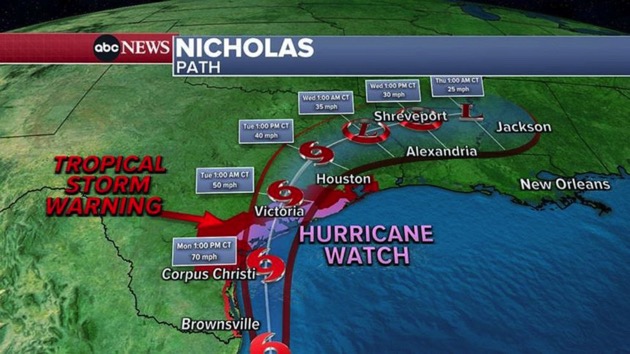
Hurricanes have 74 miles per hour or higher winds, and on Monday night, Nicholas reached sustained winds of 76 mph with higher gusts, according to the National Weather Service. The hurricane roared ashore Tuesday at around 12:30 a.m. CT on the eastern part of Texas’ Matagorda Peninsula, about 10 miles southwest of Sargent Beach. Maximum sustained winds at that time were 75 mph with higher gusts at landfall, according to the National Weather Service.
But by 4 a.m. CT, the National Weather Service said Nicholas had already been downgraded to a tropical storm with maximum sustained winds of 70 mph. Hurricane watches and warnings in the region were discontinued, while tropical storm warnings were in effect from Sabine Pass to Cameron, Louisiana, from Matagorda to Freeport, Texas, and from Matagorda to Cameron, Louisiana.
Although Nicholas is forecast to weaken further over the next couple of days as the storm moves over land, the National Weather Service warned that it could still cause life-threatening flash floods across the Deep South.
Heavy rain, flash flooding, dangerous storm surge, isolated tornadoes and strong gusty winds were expected in Texas and Louisiana. A high-risk alert for “life-threatening” flash flooding was in effect for portions of southeast Texas overnight.
The high-risk areas stretch from Matagorda to Galveston to Port Arthur. Rain totals are predicted to be between 6 and 12 inches to isolated maximum amounts of up to 18 inches, according to the latest forecast from the National Weather Service.
Some spots across southeast Texas, southern-central Louisiana and southern Mississippi could see near 10 inches of rainfall through Thursday. President Joe Biden approved an emergency declaration for Louisiana on Monday night ahead of Nicholas’ arrival.
Texas Gov. Greg Abbott issued a disaster declaration for 17 counties and has prepped resources, including boat teams and rescue aircrafts, to assist any affected areas.
In Houston, the heaviest rain will come Monday night, and flash flooding is possible.
In Harris County, which encompasses Houston, Judge Lina Hidalgo warned Monday afternoon: “We could get 10 to 15 inches of rain over the next 24 hours or so — and that would be very, very concerning.”
All public health testing and vaccination sites will stop operations in Harris County. Schools in Houston will be closed on Tuesday.
“What I need each resident of this county to do today is to get to where you are going to be by 6 p.m. tonight and stay there,” Hidalgo said.
Nicholas is slow-moving and will likely remain in Texas from Monday to Wednesday, according to the latest forecast.
Rainfall totals will be the highest around Galveston, which could see more than 10 inches.
Storm surge could be as high as 5 feet south of Galveston.
On Tuesday, Nicholas is forecast to bring heavy rain to eastern Texas and into Louisiana. By Wednesday, some of the heavy rain will begin to reach New Orleans.
Louisiana Gov. John Bel Edwards declared a state of emergency in anticipation of Nicholas. Residents are still recovering from devastating hurricanes Laura and Ida.
During a news conference on Monday, Bel Edwards warned residents to take the storm seriously, even though it hadn’t reached hurricane status. More than 119,000 customers are currently without power in Louisiana and 1,425 people are still living in shelters there due to Ida, according to the governor.
“I know that bracing for another storm while we’re still responding to and trying to recover from Hurricane Ida is not the position that we wanted to be in, but it is a situation that we are prepared for,” Bel Edwards said.
The rainfall could be as intense as 2 inches per hour.
“The most severe threat to Louisiana is in the Southwest portion of the state, where recovery from Hurricane Laura and the May flooding is ongoing. In this area heavy rain and flash flooding are possible,” the governor said in a statement. “However, it is also likely that all of South Louisiana will see heavy rain this week, including areas recently affected by Hurricane Ida. This tropical storm has the potential to disrupt some power restoration and recovery work currently underway.”
Copyright © 2021, ABC Audio. All rights reserved.